GEOLITHE performs geotechnical and hydrodynamic studies, missions of assessment and project management of consolidation of hydraulic structures. In addition, GEOLITHE is accredited under the decree 2007-1735 of MEDDE (Ministry of Ecology and Sustainable Development) to perform missions of assessment and project management on hydraulic structures such as seawalls and small dams.
Geological and geotechnical assessment of structures, analysis and evaluation of induced deformations
Modelling of internal flows, taking into account of hydrograms of floods
Study of external and internal stability, analysis of flows and hydraulic gradients
Management of specific stresses ( erosion, periodic flooding, rapid draining, internal erosion)
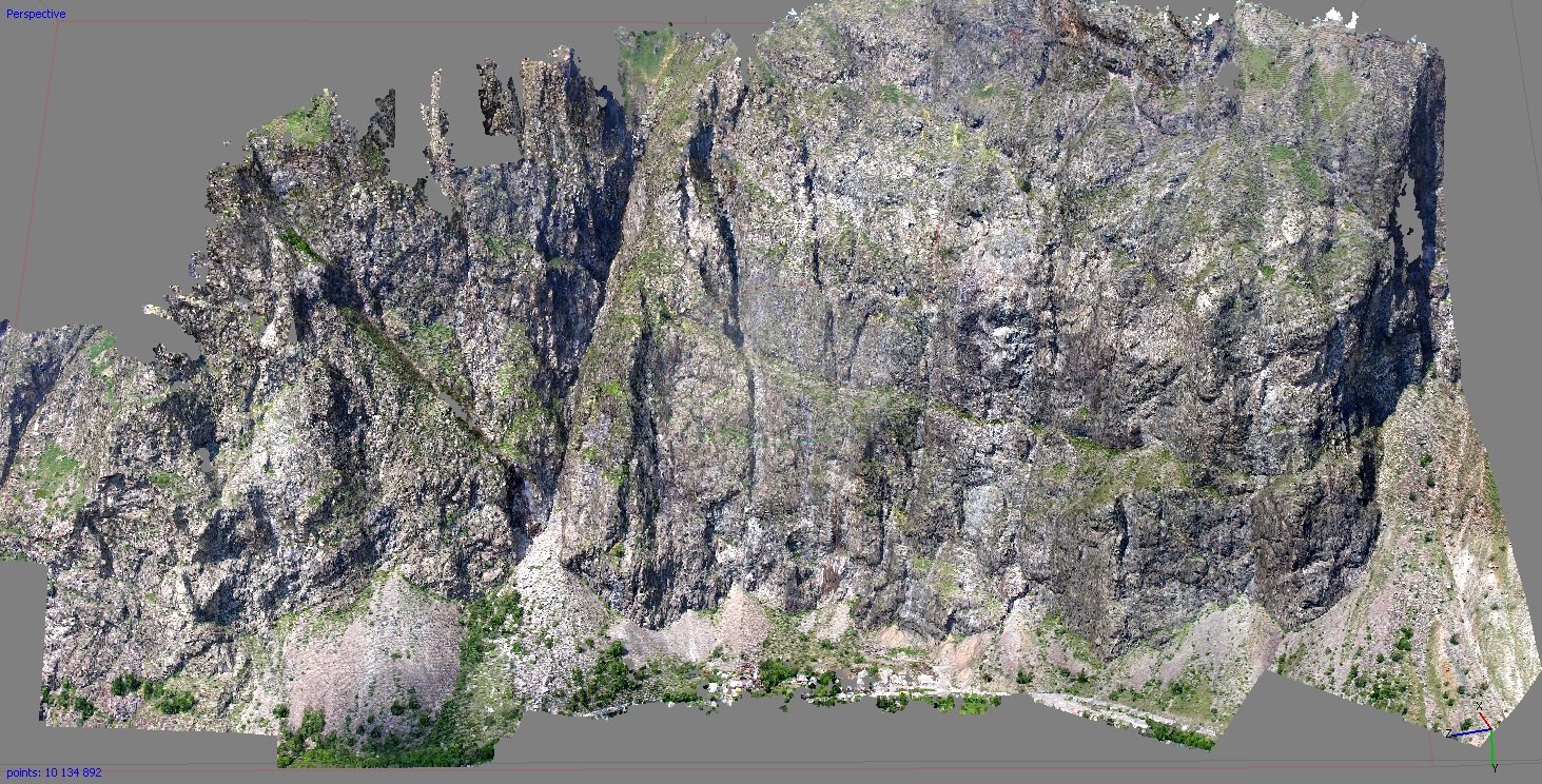
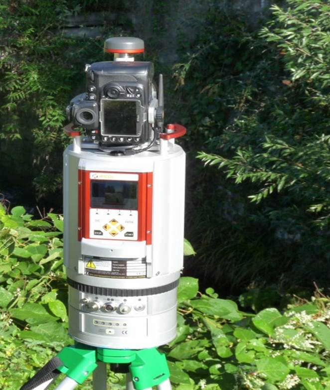
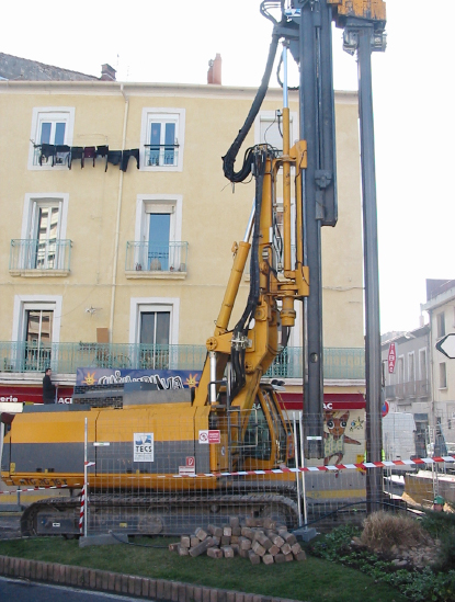
GEOLITHE intervenes on structural works (bridges, viaducts, tunnels, dams) and structures for shoring or protecting against rock-slides (galleries, screens) or avalanches (mixed barriers, grids, racks) in order to diagnose and qualify their pathologies. Our teams of autonomous engineers-technicians, one after the other, will establish a complete mapping of the structure and will propose repair work necessary for its proper operation. Ours diagnostics and detailed inspections are performed using the methodologies of the Centre d’Etudes des Tunnels (CETU-Tunnel studies centre), IQOA (Quality Image of structures) or SETRA (Road transport and route layout design department) Lasergrammetry and photogrammetry tools or the use of drones (measurements, photography) are implemented depending upon the configurations of the sites and structures.
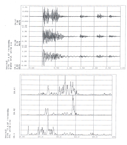
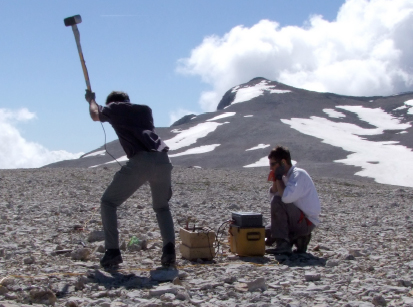
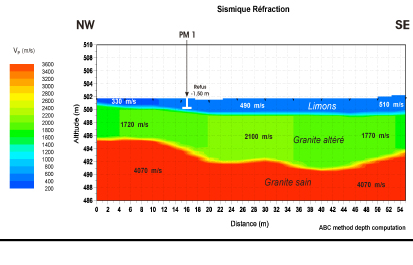
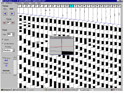
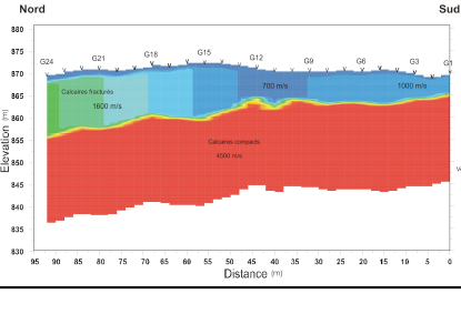
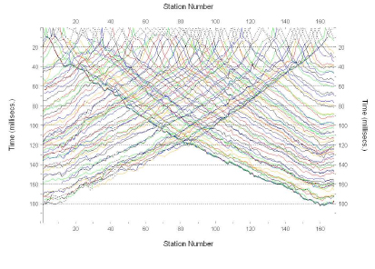
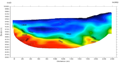
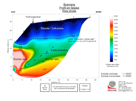
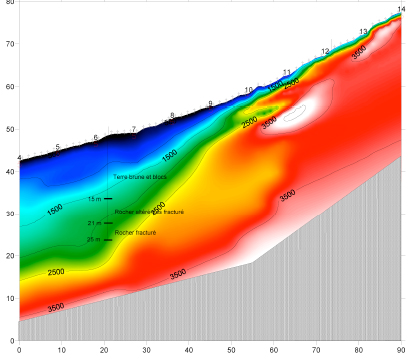
The seismic refraction allows an accurate cross-section of different layers of the sub-soil to be obtained, individualised by their thickness and their seismic velocity (P wave velocity).
Investigation in depth
System 60 m : environ15 m. System 120 m : environ 30 m. System de 240 m : de 50 à 60 m.
Applications
Rock sub-strata examinations
Localisation of fracture or faulted zones.
Determination of the tendency for landsliding
Recognition of aquifers
Etc.
Our Means
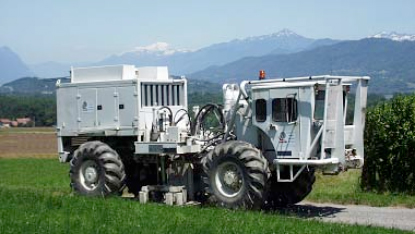
We have modern and very efficient seismic laboratories (24 and 64 channels) We use every type of source (hammer, seismic rifle, weight dropping, explosives, etc.) GEOLITHE interprets the data with methods which allow the depth of different seismic horizons to be calculated for each geophone (ABC method, Plus-Minus method, etc.)
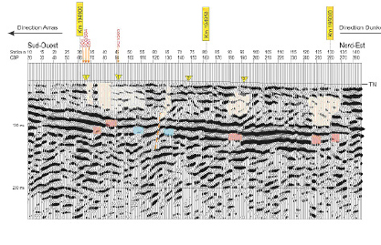
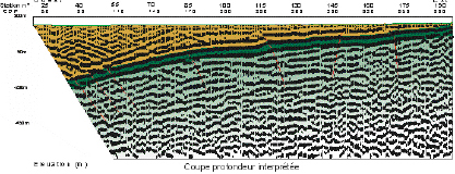
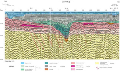
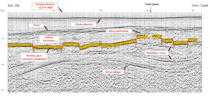
Seismic reflection allows a continuous, detailed image to be obtained of the horizontal and vertical structural extension of different geological horizons.
Investigation in depth
THR: from 0 to several hundreds of meters. HR: from several tens to several thousands of meters.
Applications
Hydrology Searches for deep water reservoirs or hydrothermal sites.
Civil engineering: Reconnaissances for tunnels, dams, etc.
Geological risk: Search for cavities.
Underground storage
Resource : Prospecting for deposits of useful substances
Our Means
We use all types of seismic sources (P or S wave vibrators, explosives, seismic rifles, weight dropping accelerated and non-accelerated, etc.) We possess modern, efficient seismic laboratories which allow us to perform acquisitions with several hundreds of plots.
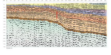
Seismic reflection allows a continuous, detailed image to be obtained of the horizontal and vertical structural extension of different geological horizons.
Investigation in depth
THR: from 0 to several hundreds of meters.
Applications
Reconnaissance of surface sediments (geometry of deposits and correlations)
Coastal layouts and river mouths
Installation of marine structures and
Sea floor mapping
Search for granulates
Our Means
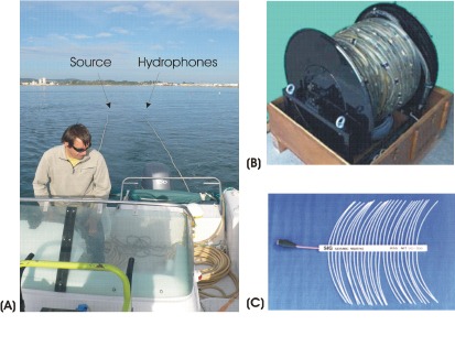
We use all types of seismic sources (Sparkers, Boomers, Air cannons, etc.) The digital acquisitions are performed with modern, efficient seismic laboratory systems (Delph Seismic, geometrics, etc.)
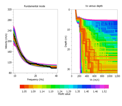
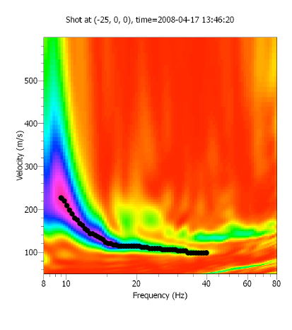
ASW allows on the one hand terrains to be qualified and on the other, (unlike seismic refraction) layers to be determined at a much slower speed (and therefore the information is more accurate concerning the type of terrain than seismic refraction).
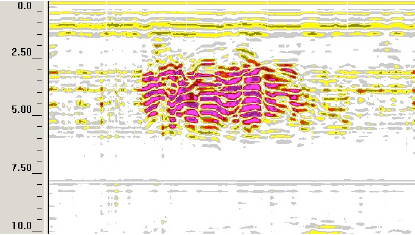
Seismic tomography allows the sub-soil or a structure to be imaged, either from the surface or from drill-holes and galleries. A cross-section of the spatial distribution of seismic speeds is obtained for the section by means of mathematical processing of all of the data.
Advantage of the method
This method allows zones to be determined at lower speed.
Applications
Inspection of structural works, dams.
Civil engineering: Reconnaissances for tunnels, dams, etc.
Geological risk: Search for cavities.
Underground storage
Monitoring of injection work
Resource : Prospecting for deposits of useful substances
Our Means
We use the program RAYFRACT which is one of the most efficient. Only GEOLITHE and BRGM have this software in France. We possess modern, efficient seismic laboratory systems which allow us to perform acquisitions with several hundreds of plots.
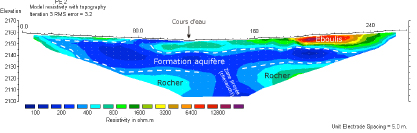
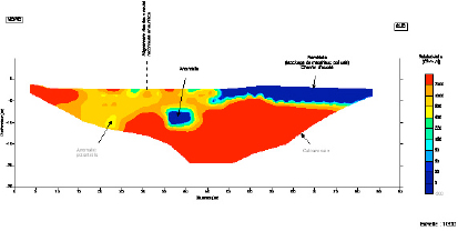
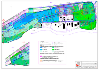
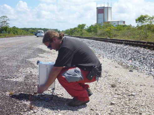
The different electrical methods allow the distribution of apparent resistivity to be obtained either at a point (probing) or on a cross-section (panel). The spontaneous potential method can be used to determine water flows in the soil. Induced polarisation can provide information on the ability of the soil to be loaded and therefore indirectly on its clay content. Investigation in depth Down to 300-400 metres.
Applications
Quarries: estimation of the volume and the quality of the deposits, localisation of clayey zones, determination of fault zones, etc.
Hydrology Search for underground water, determination of the thickness of aquifers, search for furrows, etc.
Civil engineering: determination of fracturing, of fault zones, of the presence of clay, search for lithological contact, etc.
Environment: mapping of the contaminants layer, search for full cavities, etc.
Quarries: estimation of the volume and the quality of the deposits of alluvial materials, localisation of clayey zones, thickness of the discoveries, etc.
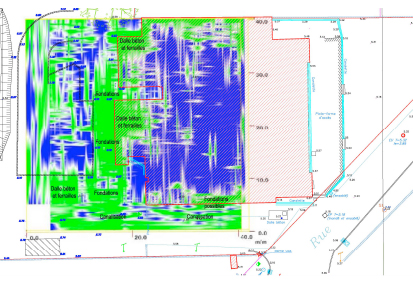
Cartographie des points durs (vieilles fondations)
Result supplied
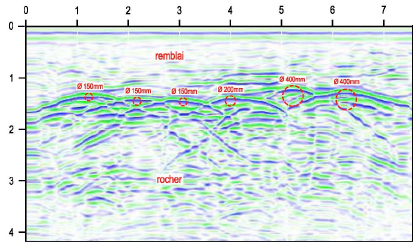
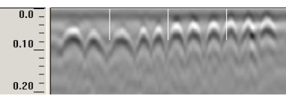
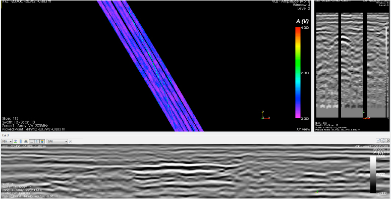
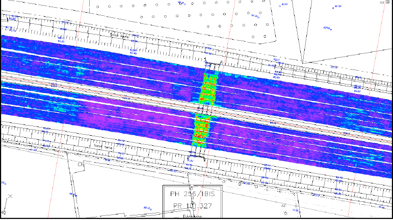
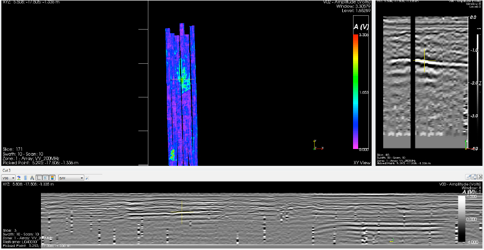
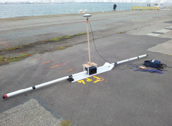
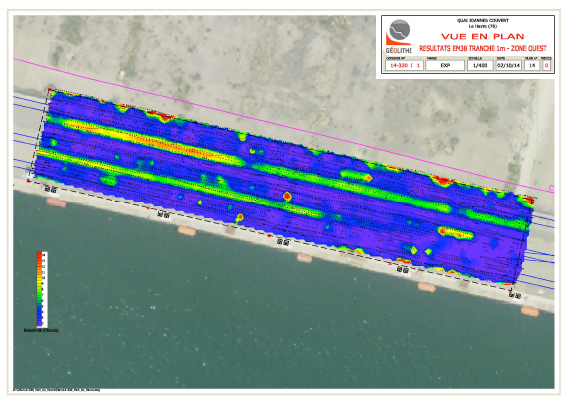
Geological radar allows a continuous, detailed image to be obtained of the geometry of different geological horizons. Investigation in depth Antennas THF (! 1500 MHz): from 0 to 30 cm. Antennas HF (900-1500 MHz): from 0 to 80 cm. Antennas MF (200-500 MHz): from 0.5 to 6 m. Antennas BF (70-100 MHz): from 2 to 15 m. Antennas TBF (« 70 MHz): from 5 to 30 m.
Applications
Reconnaissance of geological and hydro-geological structures (depth of rocks, precise localisation of faults, detection of large blocks, etc.)
Localisation of natural or man-made cavities.
Detection and localisation of pipework (metal, concrete, PVC).
Detection and localisation of buried objects (drums, tanks, old foundations, etc.).
Localisation of polluted zones.
Inspection of the thickness of galleries and tunnels.
This method allows the profiles of conductivities or conductivity iso-value maps to be obtained for a slice of land whose thickness depends on the apparatus and the law of conductivity of the site studied.
Investigation in depth
Down to a hundred meters.
Applications
Hydrology Search for underground water
Civil engineering: determination of fracturing, of the presence of clay, etc.
Environment: mapping of the layer of contaminants
Archaeology
Resource : Prospecting for deposits of useful substances
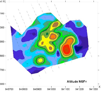
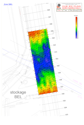
Microgravimetry is one of the methods the best adapted for the search for underground density anomalies (cavities, sinkholes, decompression, galleries…). The Microgravimetry allows relative values of the ground surface gravity to be measured in order to establish the distribution of underground densities.
Result supplied
Bouguer anomaly map. Individualisation of different anomalies by the establishment of a residual anomaly map.
Investigation in depth
Down to 50 metres.
Applications
Civil engineering: Search for shallow cavities (old quarries, galleries, karst cavities) filled in or flooded to a greater or lesser extent.
Hydrology Search for karst zones and alluvial alterations, etc.
Mines: Search of furrows and massif, dense clusters, search for fractured zones or zones of alteration, low density zones, etc.
Environment: Objects and targets to detect.
Engineers-consultants in geology, geophysics and geotechnical science

 GEOLITHE performs geotechnical and hydrodynamic studies, missions of assessment and project management of consolidation of hydraulic structures. In addition, GEOLITHE is accredited under the decree 2007-1735 of MEDDE (Ministry of Ecology and Sustainable Development) to perform missions of assessment and project management on hydraulic structures such as seawalls and small dams.
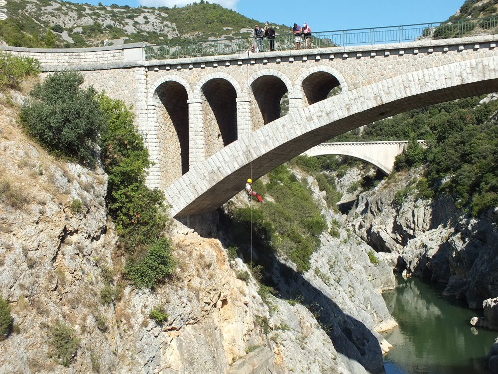 GEOLITHE intervenes on structural works (bridges, viaducts, tunnels, dams) and structures for shoring or protecting against rock-slides (galleries, screens) or avalanches (mixed barriers, grids, racks) in order to diagnose and qualify their pathologies. Our teams of autonomous engineers-technicians, one after the other, will establish a complete mapping of the structure and will propose repair work necessary for its proper operation. Ours diagnostics and detailed inspections are performed using the methodologies of the Centre d’Etudes des Tunnels (CETU-Tunnel studies centre), IQOA (Quality Image of structures) or SETRA (Road transport and route layout design department) Lasergrammetry and photogrammetry tools or the use of drones (measurements, photography) are implemented depending upon the configurations of the sites and structures.